How Many District in Maharashtra? Maharashtra has 36 districts divided across 6 revenue divisions, each with administrative, cultural, and economic importance. From Mumbai City, the smallest but richest district, to Ahmednagar, the largest by area, this blog outlines their names, sizes, and proposed future districts as of 2025.
Districts form the backbone of Maharashtra’s governance, differing in size, population, economic activity, and development levels. Every district is led by a District Collector, who plays a vital role in maintaining law and order, implementing government policies, and overseeing all aspects of local administration. To ensure smooth governance, districts are divided into talukas, towns, and villages, creating a well-structured administrative framework. This hierarchical system allows for efficient delivery of public services, coordination of development programs, and monitoring socio-economic progress across the state.
By dividing the state into these administrative units, Maharashtra ensures governance reaches every community, facilitating equitable growth, strengthening local institutions, and promoting inclusive development. Such a system helps address regional needs effectively while maintaining law, order, and public welfare throughout the state.
Exploring Maharashtra
1. Historical Origins
On May 1, 1960, the state of Maharashtra, meaning “The Great State,” was established. But its history goes way back. Many ancient empires like the Mauryas, Satavahanas, Chalukyas, and the powerful Marathas have ruled this land. Chatrapati Shivaji, a legendary figure, led the Maratha Empire and left a lasting legacy. This rich history is a big part of what makes Maharashtra what it is today.
2. Geographical Diversity
Maharashtra is a fascinating state with beautiful nature and bustling city life. From the famous skyline of Mumbai to the peaceful hills, it offers a wide range of experiences. Do you have any specific questions about Maharashtra? Its diversity helps create vibrant agriculture and unique landscapes.
3. The Western Ghats
The Western Ghats in Maharashtra are a beautiful mountain range with many plants and animals. It’s an excellent place for people who love nature and want to trek. It’s a peaceful escape from city life.
4. Urban Hubs
In Maharashtra, you’ll find lively cities like Mumbai and Pune. People recognize Mumbai as the “City of Dreams” as a central hub for finance and entertainment. It’s a diverse and bustling place with a big film industry. Pune is famous for its schools and a center for new ideas and technology.
5. Vidarbha’s Arid Landscapes
In the eastern part of Maharashtra, Vidarbha looks very different with its dry landscapes. The area has some challenges because of its semi-dry climate, but it’s still an essential place for farming. Farmers in Vidarbha are good at growing crops in these conditions, which helps the state’s agriculture.
6. Agricultural Wealth
Maharashtra has different types of land for farming. They grow rice and sugarcane in the flat areas and grapes and oranges in the hilly regions. Maharashtra is vital for India’s food. It has cities, nature, and dry places like the Western Ghats. Maharashtra shows how India can be different and still do well.
7. Economic Powerhouse
Mumbai, situated in Maharashtra, is India’s financial capital. Maharashtra contributes 14% to India’s total economic output, known as Gross Domestic Product (GDP). Its strong economy comes from its location, industries, business centers like Mumbai, and the services sector.”
8. Historical Treasures: The Forts
The state of Maharashtra has 350 forts. Each of these forts has its own story and history. Some famous ones are Raigad, Sinhagad, and Pratapgad. These forts are like time machines that take us back to different times and battles. They’re not just old walls; they’re like windows to the past.
In a nutshell, Maharashtra is a land of history, diverse landscapes, economic strength, and an abundance of forts. It continues to play a crucial role in India’s growth and has a rich cultural tapestry worth exploring.
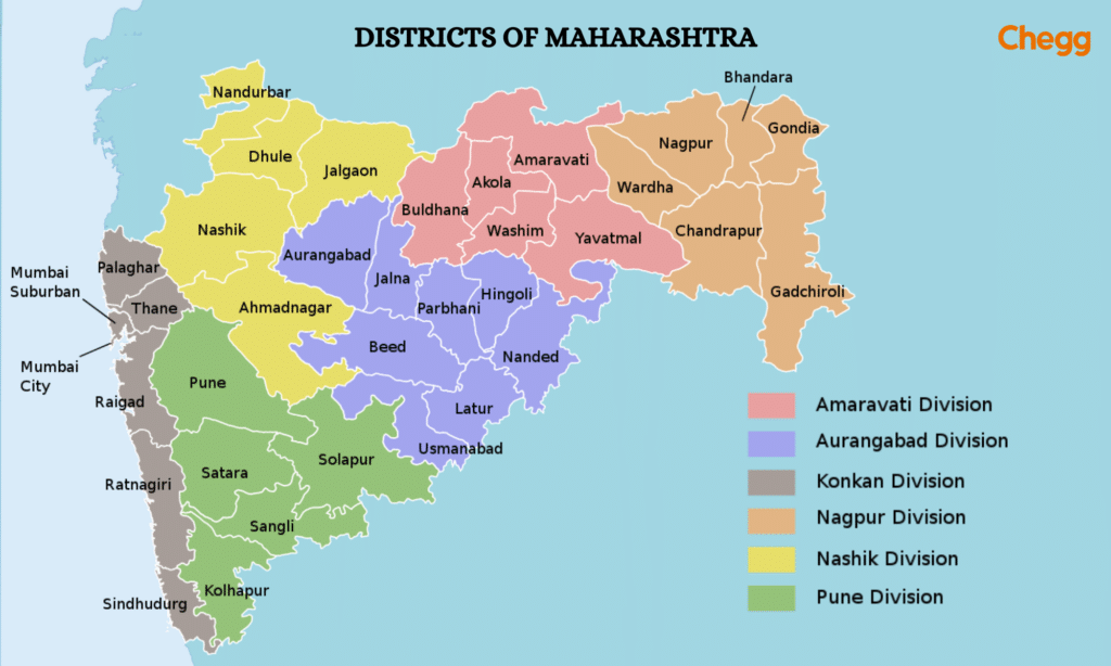
Administrative Divisions of Maharashtra
The Maharashtra state is divided into 6 revenue divisions, each consisting of multiple districts:
| Revenue Division | Districts |
|---|---|
| Amravati | Akola, Amravati, Buldhana, Washim, Yavatmal |
| Aurangabad | Aurangabad, Beed, Hingoli, Jalna, Latur, Nanded, Osmanabad, Parbhani |
| Konkan | Mumbai City, Mumbai Suburban, Palghar, Raigad, Ratnagiri, Thane, Sindhudurg |
| Nagpur | Bhandara, Nagpur, Chandrapur, Gadchiroli, Gondia, Wardha |
| Nashik | Ahmednagar, Dhule, Jalgaon, Nandurbar, Nashik |
| Pune | Kolhapur, Pune, Sangli, Satara, Solapur |
How Many District in Maharashtra’s Marathwada region?
Marathwada is a proposed state and geographical area of Maharashtra, India. During the Nizam regime, it became a part of the then Hyderabad state. The region is the same as the Aurangabad district of Maharashtra. Its historical and cultural importance defines its location in the state’s southeastern part.
Marathwada District List
| District | Area (km²) |
|---|---|
| Aurangabad | 10,100 |
| Beed | 10,693 |
| Jalna | 7,687 |
| Dharashiv | 7,569 |
| Nanded | 10,528 |
| Latur | 7,157 |
| Parbhani | 6,251 |
| Hingoli | 4,526 |
Maharashtra District List
If you are curious about the number of districts in Maharashtra, here is a table showing the list of 36 districts in Maharashtra state, along with their sizes and populations.
| No | District | Area (in sq. km) | Population |
| 1 | Ahmednagar | 17,048 | 4,543,159 |
| 2 | Akola | 5,431 | 1,818,617 |
| 3 | Amravati | 12,235 | 2,888,445 |
| 4 | Aurangabad | 10,100 | 3,695,928 |
| 5 | Beed | 10,693 | 2,585,303 |
| 6 | Bhandara | 3,819 | 1,200,334 |
| 7 | Buldhana | 9,661 | 2,586,258 |
| 8 | Chandrapur | 11,443 | 2,204,307 |
| 9 | Dhule | 8,063 | 2,050,862 |
| 10 | Gadchiroli | 14,412 | 1,072,942 |
| 11 | Gondia | 5,431 | 1,322,331 |
| 12 | Hingoli | 4,526 | 1,177,345 |
| 13 | Jalgaon | 11,765 | 4,224,442 |
| 14 | Jalna | 7,718 | 1,959,046 |
| 15 | Kolhapur | 7,685 | 3,876,001 |
| 16 | Latur | 7,157 | 2,454,196 |
| 17 | Mumbai City | 157 | 3,085,411 |
| 18 | Mumbai Suburban | 369 | 9,356,962 |
| 19 | Nagpur | 9,892 | 4,653,171 |
| 20 | Nanded | 10,529 | 3,361,292 |
| 21 | Nandurbar | 5,099 | 1,648,295 |
| 22 | Nashik | 15,530 | 6,107,187 |
| 23 | Osmanabad | 7,569 | 1,660,311 |
| 24 | Palghar | 8,395 | 2,990,116 |
| 25 | Parbhani | 6,224 | 1,835,982 |
| 26 | Pune | 15,642 | 9,426,959 |
| 27 | Raigad | 7,152 | 2,634,200 |
| 28 | Ratnagiri | 8,208 | 1,612,672 |
| 29 | Sangli | 8,572 | 2,822,143 |
| 30 | Satara | 10,480 | 3,003,741 |
| 31 | Sindhudurg | 5,207 | 849,651 |
| 32 | Solapur | 14,895 | 4,317,756 |
| 33 | Thane | 9,558 | 11,060,148 |
| 34 | Wardha | 6,309 | 1,300,774 |
| 35 | Washim | 5,150 | 1,196,714 |
| 36 | Yavatmal | 13,582 | 2,772,348 |
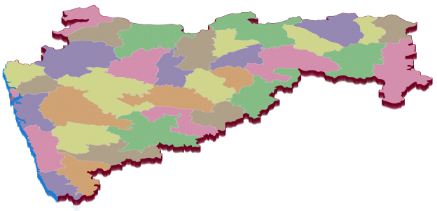
Maharashtra Map with Districts
A detailed Maharashtra district map showcases all 36 districts and their unique characteristics, making exploring the state’s diverse regions easy.
Timeline of District in Maharashtra
The government of Maharashtra added a few more districts over time to the 26 districts in Maharashtra that existed in the newly created Indian state of Maharashtra in 1960. Here’s the Maharashtra district timeline.
How Many Districts in Maharashtra in 1960
There were about 26 Districts in Maharashtra before 1960, and below is the Maharashtra district list.
| Yavatmal | Wardha |
| Thane | Solapur |
| Satara | Sangli |
| Ratnagiri | Raigad |
| Pune | Parbhani |
| Osmanabad | Nashik |
| Nanded | Nagpur |
| Mumbai City | Kolhapur |
| Jalgaon | Dhule |
| Bhandara | Beed |
| Aurangabad | Amravati |
| Ahmadnagar | Akola |
| Chandrapur | Buldhana |
Maharashtra Districts added after 1960
| Year | Districts in Maharashtra added after 1960 |
| 1981 | Districts of Jalna and Sindhudurg were added. |
| 1982 | The districts of Latur and Gadchiroli were included. |
| 1990 | The district of Mumbai Suburban was created. |
| 1998 | Washim and Nandurbar districts were added. |
| 1999 | Hingoli and Gondia districts were established. |
| 2014 | The district of Palghar was included |
Which is the Smallest District in Maharashtra?
Mumbai City District is the smallest district of Maharashtra, covering just 157 square kilometers. It’s home to Mumbai, India’s financial hub, with about 21.3 million people. The financial sector, Bollywood, and historical landmarks like the Gateway of India and Chhatrapati Shivaji Terminus make the district well-known.
The Mumbai City District may be small but significantly impacts Maharashtra and the whole country. It’s an important financial and cultural center with a large population, making it a standout district in Maharashtra.

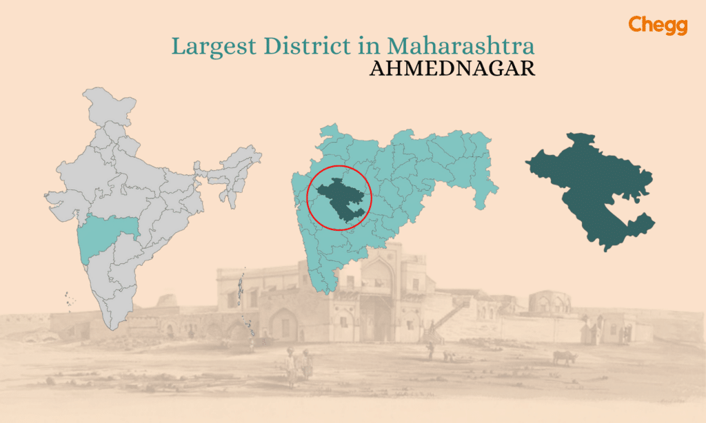
Which is the Largest District in Maharashtra?
Ahmednagar is the largest district in Maharashtra, known for its rich history and culture. It’s famous for the Shirdi Sai Baba Temple, a popular pilgrimage site. The district also has forts, monuments, and historical sites from the Maratha Empire. People also know Ahmednagar for its agriculture. It’s a great place to explore Maharashtra’s diverse heritage.
What are the New Districts in Maharashtra?
Maharashtra, a state known for its diverse landscape and growing population, is considering creating new districts to make governing and administration easier. Here’s the Maharashtra district list, along with some details about each:
- Nashik District (from Malegaon & Kalwan): Proposed from Malegaon and Kalwan.
- Thane District (from Mira-Bhainder & Kalyan): Expands by incorporating these areas.
- Buldana District (from Khamgaon): Encompasses regions known for agriculture and cotton.
- Achalpur District (from Amravati): Formed from Amravati, known for education and culture.
- Sakoli District (from Bhandara): Rich in forestry and natural resources.
- Chimur District (from Chandrapur): Separate from Chandrapur, it is known for coal and wildlife.
- Aheri District (from Gadchiroli): Part of Maharashtra’s tribal belt.
- Bhusawal District (from Jalgaon): Agricultural and industrial hub.
- Udgir District (from Latur): Culturally and historically significant.
- Ambejogai District (from Beed): Known for its religious and historical importance.
- Kinwat District (from Nanded): Rich historical background.
- Mandesh District (from Satara): Famous for strawberries and culture.
Geographical, Economic, and Cultural Significance of Maharashtra Districts
| District | Geographical Significance | Economic Significance | Cultural Significance |
|---|---|---|---|
| Mumbai City | Coastal area, India’s financial hub | Finance, entertainment industry | Cosmopolitan lifestyle, center for Bollywood |
| Mumbai Suburban | Urban sprawl along the coast | Residential zones, commercial centers | Cultural diversity, bustling urban environment |
| Thane | Coastal and hilly regions | IT sector, industrial development | Heritage sites, vibrant festivals |
| Palghar | Coastal belt with forest cover | Tourism, industrial expansion | Tribal heritage, scenic beauty |
| Raigad | Coastal area with forts | Agriculture, tourism, and industries | Historical monuments, coastal lifestyle |
| Ratnagiri | Scenic beaches along the coast | Mango farming, fishing, tourism | Konkan cuisine, traditional arts |
| Sindhudurg | Pristine beaches, coastal environment | Agriculture, fishing, tourism | Ancient forts, temples, local crafts |
| Pune | Hilly region with fertile plains | Education, IT, manufacturing | Renowned for classical music and institutions |
| Satara | Hilly and fertile terrain | Agriculture, tourism, industries | Historical sites, hill stations |
| Sangli | Riverbank location, fertile plains | Sugarcane farming, industries | Religious festivals, temples |
| Kolhapur | Fertile land, known for heritage sites | Agriculture (jaggery), manufacturing | Wrestling culture, Kolhapuri cuisine |
| Solapur | Arid plains, historic importance | Textiles, agriculture | Religious fairs, local festivals |
| Nashik | Hilly area, vineyards | Wine production, agriculture | Kumbh Mela, pilgrimage tourism |
| Dhule | Agricultural landscape, riverside | Cotton farming, small industries | Local crafts, traditional fairs |
| Nandurbar | Hilly region, tribal population | Handicrafts, agriculture | Tribal traditions, festive events |
| Jalgaon | Agricultural plains by rivers | Banana and cotton farming, industries | Ajanta caves, pilgrimage sites |
| Ahmednagar | Fertile plains with heritage landmarks | Grapes and sugarcane farming, industries | Historic monuments, religious events |
| Aurangabad | Hilly area, UNESCO heritage sites | Tourism, auto-manufacturing sector | Cultural festivals, heritage tourism |
| Jalna | Agricultural land, historical relevance | Pharmaceutical industries, agriculture | Historic monuments, cultural festivals |
| Beed | Arid region with historical importance | Agriculture, small industries | Ancient forts, cultural heritage |
| Osmanabad | Arid plains with notable landmarks | Small-scale industries, agriculture | Folk arts, historic sites |
| Nanded | Fertile land, pilgrimage significance | Religious tourism, agriculture | Sikh pilgrimage center, historical significance |
| Latur | Arid plains with educational relevance | Agriculture, educational institutions | Historic forts, traditional music |
| Hingoli | Arid terrain with historic landmarks | Small industries, agriculture | Local festivals, cultural heritage |
| Parbhani | Arid plains, historic background | Education, agriculture | Cultural events, monuments |
| Amravati | River plains, cotton-growing region | Agriculture, manufacturing | Cultural activities, historical sites |
| Akola | Plains along rivers | Cotton industries, agriculture | Cultural festivals, monuments |
| Yavatmal | Plains and riverside terrain | Cotton and soybean farming, industries | Folk arts, local celebrations |
| Buldhana | Agricultural land along rivers | Industry, agriculture | Religious and historical sites |
| Washim | Plains by rivers | Agriculture, small industries | Local fairs, historical landmarks |
| Nagpur | Central location, “Orange City” | Trade, education, industries | Cultural events, historic landmarks |
| Wardha | Agricultural land with historic sites | Textile industries, agriculture | Gandhian heritage, cultural events |
| Bhandara | Forested land near rivers | Agriculture, industry | Wildlife sanctuaries, tribal culture |
| Gondia | Forested area by rivers | Agriculture, small-scale industries | Traditional crafts, wildlife sanctuaries |
| Chandrapur | Forested terrain with minerals | Mining, agriculture, industry | Wildlife sanctuaries, local festivals |
| Gadchiroli | Dense forests with tribal populations | Agriculture, forest produce | Eco-tourism, tribal culture |
Interesting Facts About Maharashtra
- Cultural and Historical Hub: Maharashtra is a melting pot of cultures, languages, and traditions. Festivals like Ganesh Chaturthi and Gudi Padwa are celebrated enthusiastically across the state. Its rich history is reflected in landmarks such as the Ajanta and Ellora caves, Shivaji Maharaj’s forts, and Pune’s Peshwa heritage, making it a significant cultural and historical tourism center.
- Economic Powerhouse: Maharashtra boasts the largest economy among Indian states, fueled by industries like technology, entertainment, finance, and agriculture. Cities like Mumbai serve as financial hubs, while industrial areas contribute to manufacturing, making the state a key driver of India’s economic growth.
- Geographical Diversity: The state offers varied landscapes, from the lush hills of the Western Ghats to scenic coastal beaches. Hill stations like Lonavala and Mahabaleshwar attract tourists for their natural beauty, while wildlife sanctuaries such as Tadoba, Pench, and Sanjay Gandhi National Park showcase Maharashtra’s rich biodiversity.
- Entertainment Capital: Mumbai, the state’s capital, is the heart of Bollywood, India’s largest film industry. Known as the Gateway of India, Mumbai is also a major tourist attraction, drawing visitors worldwide.
- Cuisine and Agriculture: Maharashtra is famous for its diverse cuisine, including spicy misal pav and sweet puran poli. The state is also an agricultural leader, producing crops like sugarcane, cotton, and grapes, contributing significantly to India’s food and economic resources.
Latest Updates: Proposed New Districts in Maharashtra
- In a significant move to enhance administrative efficiency, the Maharashtra government is set to divide existing districts into 21 new ones.
- This proposal aims to improve governance and accelerate local development across the state.
- An official announcement regarding this major administrative reform is expected on January 26, 2025.
Conclusion
In summary, this article explains how many district in Maharashtra are there and highlights their unique significance. Maharashtra’s 36 districts reflect a rich cultural, historical, and economic development blend. Each district has its own character, from the bustling urban life of Mumbai to the tranquil villages along the Konkan coast. While Ahmednagar, the largest district by area, is known for its agricultural and religious importance, Thane stands out as the most populated, representing the state’s rapid urbanization and industrial growth. Smaller districts like Sindhudurg and Bhandara showcase Maharashtra’s natural beauty and biodiversity. Beyond administrative purposes, these districts preserve heritage, foster economic activity, and promote regional identity.
Discussions about proposed new districts demonstrate the state’s focus on improving governance and accessibility. Overall, the districts of Maharashtra symbolize the state’s harmony between tradition and modernity, combining historical landmarks, thriving cities, and scenic landscapes. By understanding how many districts in Maharashtra exist, readers gain insight into each region’s diversity, culture, and importance.
Read More:-
- How Many Districts in Karnataka? | An Overview
- How Many Districts in West Bengal? Brief Overview
- How Many Districts in India: State Wise List of Districts
Frequently Asked Questions (FAQs)
How many districts are there in Maharashtra in 2025?
Maharashtra has 36 districts, which are further divided into 6 revenue divisions and 109 sub-divisions of the 357 talukas.
What are the 7 divisions of Maharashtra?
Maharashtra is divided into 6 administrative divisions: Konkan, Pune, Nashik, Aurangabad, Amravati, and Nagpur. These divisions are further divided into 36 districts.
Which is the smallest district in Maharashtra?
The smallest district in Maharashtra in terms of area is Mumbai City, which is only 157 square kilometers.
Which district is the newest in Maharashtra?
Palghar is Maharashtra’s newest district. The Maharashtra government created it on August 1, 2014.
Which is the 36 district in the Maharashtra list 2025?
Palghar is Maharashtra’s 36th district. It was carved out of Thane district and officially declared a separate district on August 1, 2014. As of 2025, Palghar remains the most recent addition, making the total district in Maharashtra 36.