Do you know how many district in India there are? Total district in India are approximately 800 as per the latest data of 2025, From language to food, there’s a wide range of diversity in the districts of India. Each district is an administrative unit of India because of the country’s large area and population.
A district is a specific area within a larger region, often defined for administrative, political, or organizational purposes. For example, a city might be divided into districts for managing services or elections. There are a total of 800 districts in India. Understanding the number of districts is essential for various administrative functions, resource allocation, and governance. Therefore, when asking “How Many District in India,” it is vital to note that this number can change due to administrative reorganization or the creation of new districts to serve the population better.

What is a District?
Before going any further on how many districts in India there are, let us know what a district is. The districts in India are territorial divisions. These divisions ensure the proper functioning of administrative and judicial features. The total number of districts in India as of 2025 is 800.
Administrative Functions of a District
The most essential functions of districts are:
- To help launch central schemes and policies at the grassroots level.
- To function as an intermediary between the state and central governments.
- Disaster management on a local level is also the responsibility of districts.
Comparative Analysis of Districts Worldwide
India is not the only country with districts. Countries like the US and China also have district-level governance.
- The US districts are called counties. There are 3006 counties in the US.
- Similarly, China has a total of 1355 counties.
How Many States in India?
With the creation of states based on the languages spoken in various areas, the States Reorganisation Act of 1956 significantly changed India’s political landscape. India has 28 states and 8 Union Territories as a result of this division. There are currently 400 cities in the entire nation. Eight major metropolises comprise these cities: Bangalore, Hyderabad, Chennai, Pune, Ahmedabad, New Delhi, Mumbai, Kolkata, and Hyderabad. Understanding “How Many District in India” is essential for grasping the country’s administrative structure, as it reflects the organization of governance and resource distribution across these diverse regions.
There are 28 states and 8 union territories in India. Every place has unique aspects, such as cuisine, language, and tourist attractions. Kerala features serene waterways, while Maharashtra features busy cities. There are prominent forts in Rajasthan and beautiful valleys in Himachal Pradesh. These locations add diversity and interest to India. They have their leaders and are crucial to the development of India. Understanding “How Many District in India” is essential, as each state and Union Territory is further divided into districts, which are vital for local governance and administration, ensuring that the unique needs of each region are addressed effectively.
Number of Districts in Each State
| STATES | DISTRICTS | District Names |
| ANDHRA PRADESH | 13 | Allurisitharamaraju, Ananthapuramu, Annamayya, Anakapalli, Baptla, Chittoor, East Godavari, Eluru, Guntur, Kakinada, Konaseema, Krishna, Kurnool, Nandyal, N.T.R, Palnadu, Parvathipurammanyam, Prakasam, Srisathyasai, SPS Nellore, Srikakulam, Tirupati, Visakhapatnam, Vizianagaram, West Godavari, and YSR Kadapa |
| ARUNACHAL PRADESH | 26 | Anjaw, Changlang, Dibang Valley, East Kameng, East Siang, Itanagar, Kra Daadi, Kurung Kumey, Lohit, Longding, Lower Dibang Valley, Lower Subansiri, Namsai, Papumpare, Shiyomi, Siang, Tawang, Tirap, Upper Siang, Upper Subansiri, West Kameng, and West Siang. |
| ASSAM | 33 | Baksa, Barpeta, Bongaigaon, Cachar, Charaideo, Chirang, Darrang, Dhemaji, Dhubri, Dibrugarh, Dima Hasao, Goalpara, Golaghat, Hailakandi, Jorhat, Kamrup Metropolitan, Kamrup, Karbi Anglong, Karimganj, Kokrajhar, Lakhimpur, Majuli, Morigaon, Nagaon, Sivasagar, Sonitpur, South Salmara- Mankachar, Tinsukia, Udalguri, and West Karbi Anglong. |
| BIHAR | 38 | Araria, Arwal, Aurangabad, Banka, Begusarai, Bhagalpur, Bhojpur, Buxar, Darbhanga, East Champaran, Gaya, Gopalganj, Jamui, Jehanabad, Kaimur, Katihar, Khagaria, Kishanganj, Lakhisarai, Madhepura, Madhubani, Munger, Muzaffarpur, Nalanda, Nawada, Patna, Purnea, Rohtas, Saharsa, Samastipur, Saran, Sheikhpura, Sheohar, Sitamarhi, Siwan, Supaul, Vaishali, and West Champaran. |
| CHATTISGARH | 27 | Balod, Balodabazar Bhatapara, Balrampur, Bastar, Bemetara, Bijapur, Bilaspur, Dantewada, Dhamtari, Durg, Gariaband, Gaurela Pendra Marwahi, Jangir Champa, Jashpur, Kanker, Kawardha, Kondagaon, Korba, Korea, Mahasamund, Mungeli, Narayanpur, Raigarh, Raipur, Rajnandgaon, Sukma, Surajpur, and Surguja. |
| GOA | 2 | North Goa and South Goa |
| GUJARAT | 33 | Ahmedabad, Amreli, Anand, Arvalli, Banaskantha, Bharuch, Bhavnagar, Botad, Chhotaudepur, Dahod, Devbhumi Dwarka, Gandhinagar, Gir Somnath, Jamnagar, Junagadh, Kutch, Kheda, Mahesana, Mahisagar, Morbi, Narmada, Navsari, Panchmahals, Patan, Porbandar, Rajkot, Sabarkantha, Surat, Surendranagar, Tapi, Dang, Vadodara, and Valsad. |
| HARYANA | 22 | Ambala, Bhiwani, Charkhi Dadri, Faridabad, Fathehabad, Gurugram, Hisar, Jhajjar, Jind, Kaithal, Karnal, Kurukshetra, Mahendragarh, Nuh, Palwal, Panchkula, Panipat, Rewari, Rohtak, Sirsa, Sonipat, and Yamunanagar. |
| HIMACHAL PRADESH | 12 | Bilaspur, Chamba, Hamirpur, Kangra, Kinnaur, Kullu, Lahaul and Spiti, Mandi, Shimla, Sirmapur, Solan, and Una. |
| JHARKHAND | 24 | Bokaro, Chaibasa, Chatra, Deoghar, Dhanbad, Dumka, Garhwa, Giridih, Godda, Gumla, Hazaribagh, Jamshedpur, Jamtara, Khunti, Koderma, Latehar, Lohardaga, Pakur, Palamu, Ramgarh, Ranchi, Sahibganj, Seraikela, and Simdega. |
| KARNATAKA | 30 | Bidar, Kalaburagi, Vijaypura, Yadagiri, Belagavi, Bagalkot, Raichur, Uttar Kannada, Dharwad, Gadag, Koppal, Ballari, Vijayanagar, Haveri, Davangere, Shivamogga, Udupi, Chikkamagaluru, Chitradurga, Dakshin Kannada, Kodagu, Hassan, Tumakuru, Mysuru, Mandya, Chamrajnagar, Ramanagara, Bengluru, Bengaluru Rural, Kolar, and Chikkaballapura. |
| KERALA | 14 | Alappuzha, Ernakulam, Idukki, Kannur, Kasaragod, Kollam, Kottayam, Kozhikode, Mallapuram, Palakkad, Pathanamthitta, Thrissur, Trivandrum, and Wayanad. |
| MADHYA PRADESH | 52 | Agar Malwa, Alirajpur, Anuppur, Ashokanagar, Balaghat, Barwani, Betul, Bhind, Bhopal, Burhanpur, Chhatarpur, Chhindwara, Damoh, Datia, Dewas, Dhar, Dindori, Guna, Gwalior, Harda, Indore, Jabalpur, Jhabua, Katni, Khandwa, Khargone, Mandla, Mandsaur, Mauganj, Morena, Narmadapurm, Narsinghpur, Neemuch, Niwari, Panna, Raisen, Rajgarh, Ratlam, Rewa, Sagar, Satna, Shehore, Seoni, Shahdol, Shajapur, Sheopur, Shivpuri, Sidhi, Singrouli, Tikamgarh, Ujjain, Umaria, and Vidisha. |
| MAHARASHTRA | 36 | Ahmednagar, Akola, Amravati, Aurangabad, Need, Bhandara, Buldhana, Chandrapur, Dhule, Gadchiroli, Gondia, Hingoli, Jalgaon, Jalna, Kolhapur, Latur, Mumbai City, Mumbai Suburban, Nagpur, Nanded, Nandurbar, Nashik, Osmanabad, Palghar, Parbhani, Pune, Raigad, Ratnagiri, Sangli, Satara, Sindudurg, Solapur, Thane, Wardha, Washim, and Yavatmal. |
| MANIPUR | 16 | Bishnupur, Chandel, Churachandpur, Pherzawl, Tengnoupal, Kakching, Noney, Imphal East and West, Jiribam, Kamjong, Kangpokpi, Senapati, Tamenglong, Thoubal, and Ukhrul. |
| MEGHALAYA | 11 | South West Garo Hills, West Garo Hills, North Garo Hills, East Garo Hills, South Garo Hills, West Khasi Hills, South West Khasi Hills, Easter West Khasi Hills, East Khasi Hills, Ri Bhoi, West Jaintia Hills, and East Jaintia Hills. |
| MIZORAM | 8 | Aizawl, Lunglei, Champhai, Mamit, Serchhip, Kolasib, Lawngtlai, Saiha, and Khawzawl. |
| NAGALAND | 11 | Dimapur, Kiphire, Kohima, Longleng, Mokokchung, Mon, Paren, Phek, Tuensang, Wokha, Zunheboto, Chumukedima, Niuland, Noklal, Shamator, and Tseminyu. |
| ORISSA | 30 | Angul, Balangir, Baleshwar, Bargarh, Bhadrak, Boudh, Cuttack, Deogarh, Dhenkanal, Gajapati, Ganjam, Jagatsinghpur, Jajpur, Jharsuguda, Kalahandi, Kandhamal, Kendrapara, Kendujhar, Khorda, Koraput, Malkangiri, Mayurbhanj, Nabarangpur, Nayagarh, Nuapada, Puri, Rayagada, Sambalpur, Subarnapur, and Sundargarh. |
| PUNJAB | 22 | Amritsar, Barnala, Bathinda, Faridkot, Fatehgarh Sahib, Fazilka, Ferozepur, Gurdaspur, Hoshiarpur, Jalandhar, Kapurthala, Ludhiana, Malerkotla, Mansa, Moga, Sas nagar, Sri Muktar Sahib, SBS Nagar, Pathankot, Patiala, Rupnagar, Sangrur, and Tarn Taran. |
| RAJASTHAN | 33 | Ajmer, Alwar, Banswara, Baran, Barmer, Bharatpur, Bhilwara, Bikaner, Bundi, Chittorgarh, Churu, Dausa, Dholpur, Dungarpur, Hanumangarh, Jaisalmer, Jaipur, Jalor, Jhalawar, Jhunjhunu, Jodhpur, Karauli, Kota, Nagaur, Pali, Pratapgarh, Rajsamand, Sawai Madhopur, Sikar, Sirohi, Sri Ganganagar, Tonk, Udaipur. |
| SIKKIM | 4 | Gangtok, Mangan, Gyalshinh, Namchi, Pakyong, and Soreng. |
| TAMIL NADU | 37 | Ariyalur, Chengalpattu, Chennai, Coimbatore, Cuddalore, Dharmapuri, Dindigul, Erode, Kallakurichi, Kancheepuram, Kanniyakumari, Karur, Krishnagiri, Madurai, Mayiladuthurai, Nagapattinam, Namakkal, Nilgiris, Perambalur, Pudukkottai, Ramanathapuram, Ranipet, Salem, Sivaganga, Tenkasi, Thanjavur, Theni, Thoothukudi, Tiruchirapalli, Tirunelveli, Tirupathur, Tiruvannamalai, Tiruvarur, Vellore, Viluppuram, and Virudhunagar. |
| TELANGANA | 33 | Adilabad, Hyderabad, Jagtial, Jangaon, Jayashankar Bhupalapally, Jogulamba Gadwal, Kamareddy, Karimnagar, Khammam, Bhadradri Kothagudem, Komaram Bheem Asifabad, Mahabubnagar, Mahabubabad, Mancherial, Medak, Medchal Malkajgiri, Mulugu, Nagarkurnool, Nalgonda, Narayanpet, Nirmal, Nizamabad, Pedapalli, Rajanna Sircilla, Rangareddy, Sangareddy, Siddipet, Suryapet, Vikarabad, Wanaparthy, Hanumakonda, Warangal, and Yadadri Bhuvanagari. |
| TRIPURA | 8 | Dhalai, Gomati, Khowai, North Tripura, Sepahijala, South Tripura, Unakoti, and West Tripura. |
| UTTAR PRADESH | 75 | Agra, Aligarh, Allahabad, Ahmednagar, Amroha, Auraiya, Azamgarh, Badaun, Bahraich, Ballia, Balrampur, Banda, Barabanki, Bareilly, and more. |
| UTTARAKHAND | 13 | Almora, Bageshwar, Chamoli, Champawat, Dehradun, Haridwar, Nainital, Pauri Garhwal, Pithoragarh, Rudraprayag, Tehri Garhwal, Udham Singh Nagar, and Uttarkashi. |
| WEST BENGAL | 23 | North 24 Parganas, South 24 Parganas, Bankura, Birbhum, CoochBihar, Dakshin Dinajpur, Darjeeling, Hooghly, Howrah, Jalpaiguri, jhargram, Kalimpong, Kolkata, Malda, Murshidabad, Nadia, Paschim Burdwan, Purba Burdwan, Paschim Medinipur, Purba Medinipur, Purulia, Uttar Dinajpur, and Alipurduar. |
Do you know how many district in India? There are 800 total district in India.
First District of India
Salem, located in Tamil Nadu, holds a unique place in India’s history as the first district established on April 4, 1792. (As of 2025, India has a total of 806 districts.) Originally, Salem covered a vast area of 7,530 square kilometers, which included regions now known as Namakkal, Dharmapuri, and Krishnagar districts. Understanding “How Many District in India” is essential for grasping the administrative evolution of the country, as the creation of districts like Salem reflects the historical and geographical changes that have shaped India’s governance structure over the years.
In its early years, Alexander Reed served as the district’s collector from 1792 to 1799, pivotal in shaping its administrative framework. This historical milestone highlights Salem’s significant contribution to India’s early governance and enduring legacy as a key administrative unit. Understanding “How Many District in India” is essential, as it not only reflects the current administrative structure, with a total of 806 districts as of 2025 but also underscores the historical significance of districts like Salem in the evolution of governance in the country. Each district, including Salem, has played a vital role in the development and administration of India over the years.

Read More:
- How Many District in Tamilnadu? Brief Overview of Each District
- Dry States in India: Alcohol-Banned States
Smallest District in India
Do you know the smallest district in India? Mahe, located in the Union Territory of Puducherry, is the smallest district, with an area of just 9 sq. km and a total population of 41,934.
- Despite its small size, Mahe attracts tourists from around the globe. Significant attractions include Hillock and St. Theresa Shrine, offering scenic beauty and spiritual experiences.
- However, the district faces significant challenges, especially in agriculture. Additionally, fishermen’s health in the area has declined, raising concerns about sustainable livelihoods.
Largest District in India
The largest district in India is Kutch, Gujarat. Factors that define the District size are:
- Population
- Geographical area
- Political area
- Economic and historical factors
Kutch is India’s biggest district. Let us know a bit about its economy.
- Economic factors are also crucial in determining the district’s size. The primary economic activity in the area is agriculture, and new industries have also been established.
- India’s biggest district is also famous for trade. Kutch is also a popular tourist spot.
- The largest district, Kutch, has an area of 45,652 km2 and a population of about 2,092,371.
Most Populated and Least Populated Districts in India
Most Populated District:
The most populated district in India is North 24 Parganas, West Bengal, with a population of 10,082,852. Below is the complete district list with all details.
| State | District Names | Population |
| Maharashtra | Thane | 180.50 |
| West Bengal | North 24 Parangas | 160.9 |
| Karnataka | Bangalore | 126.7 |
| Delhi | Delhi East | 120.12 |
| Delhi | Delhi North | 118.34 |
| Maharashtra | Mumbai Suburban | 115.06 |
| West Bengal | Kolkata | 112.09 |
| Telangana | Hyderabad | 95.7 |
| Maharashtra | Pune | 94.27 |
| Gujarat | Ahmedabad | 87.79 |
Least Populated District:
The least populated district in India is Dibang Valley, Arunachal Pradesh, with a population of 8,004. Below is the complete district list with all details.
| State | District Names | Population |
| Arunachal Pradesh | Dibang Valley | 7,948 |
| Arunachal Pradesh | Anjaw | 21,089 |
| Himachal Pradesh | Lahul and Spiti | 31,528 |
| Andaman & Nicobar | Nicobar | 36,842 |
| Arunachal Pradesh | Upper Siang | 35,320 |
| Arunachal Pradesh | Dibang Valley | 42,855 |
| Himachal Pradesh | Kinnaur | 84,298 |
| Arunachal Pradesh | Kurung Kumey | 89,717 |
| Arunachal Pradesh | Longding | 56,953 |
| Nagaland | Kiphire | 74,004 |
Top 10 Biggest Districts in India
The district list of the Top 10 biggest District in India is given below:
| District Name | States | Size in sq. km. (Approximate) |
| Kutch | Gujarat | 45,652 |
| Ladakh | Ladakh Union Territory | 59,146 |
| Leh | Ladakh Union Territory | 45,110 |
| Bikaner | Rajasthan | 30,247 |
| Jaisalmer | Rajasthan | 38,401 |
| Rajasthan | Rajasthan | 31,139 |
| Sikar | Rajasthan | 10,813 |
| Barmer | Rajasthan | 28,387 |
| Pali | Rajasthan | 12,456 |
| Ganganagar | Rajasthan | 11,171 |
How many Districts are there in Uttar Pradesh?
Uttar Pradesh, founded on January 24, 1950, has 75 districts and an area of 240,928 square kilometers. It is India’s largest state and also has the most districts. Every district is governed by a district magistrate employed by the Indian Administrative Service.
For better administration, the districts of Uttar Pradesh have been split up into eighteen administrative divisions, each with its headquarters. India’s most populous state has always been Uttar Pradesh. In 2011, the state’s Chief Minister, Mayawati, declared the establishment of three new UP districts: Prabuddhanagar, Panchsheel Nagar, and Bhimnagar. With a population exceeding 12 lakh people, Uttar Pradesh plays a significant role in the overall demographic landscape of India.
Understanding “How Many District in India” is crucial, as it highlights the administrative divisions within states like Uttar Pradesh, which contribute to effective governance and resource management in one of the country’s most populous regions. As of 2025, India has 806 districts, reflecting the ongoing evolution of its administrative framework.
How many District in India 2025?
India will have 800 districts in total in 2025. This number can fluctuate as the government creates new districts for administrative reasons.
Why Kutch is a Cultural and Historical Destination?
- Kutch is home to diverse cultures.
- Great Rann of Kutch is an essential landmark of the area.
- The district also has some ancient archaeological sites like Dholavira.
- The region’s native handicrafts and leatherwork are also popular.
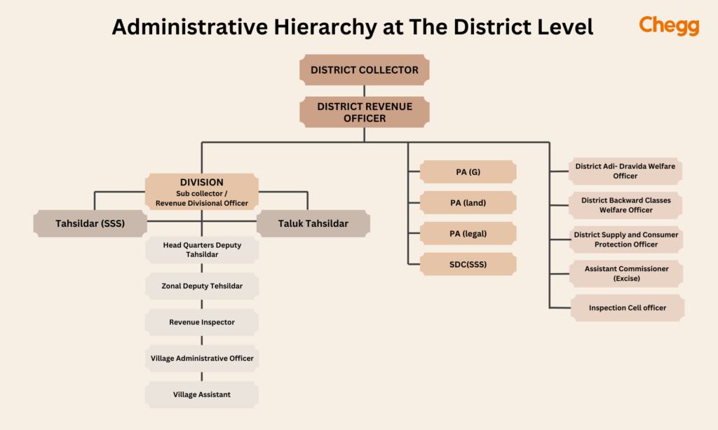
Administration of Districts in India:
The district administration in India is handled by key officials, including:
- District Magistrate, Deputy Commissioner, or District Collector: An officer from the Indian Administrative Service responsible for administration and tax collection.
- Superintendent of Police, Senior Superintendent of Police, or Deputy Commissioner of Police: A member of the Indian Police Service tasked with maintaining law and order.
- Deputy Conservator of Forests: An employee from the Indian Forest Service overseeing the district’s forests, environment, and wildlife
Understanding “How Many District in India” is essential, as it provides insight into the country’s administrative structure, which currently consists of 806 districts as of 2025. Each district plays a vital role in governance, and the unique operational frameworks of certain districts highlight the diversity in administrative practices across India. This complexity is crucial for effective governance and resource allocation in various regions.
New Districts in India
The Union Territory of Ladakh witnessed a significant administrative change in 2023 with the announcement of five new districts. This expansion from two to seven districts marks a significant milestone for the region, fulfilling a long-standing demand of residents.
The Newly Formed Districts
The five newly created districts in Ladakh are:
- Zanskar: Known for its picturesque landscapes and monasteries, Zanskar is a culturally rich region.
- Drass: The coldest permanently inhabited place in India, Drass is a strategically important region.
- Sham: A remote and sparsely populated region, Sham offers breathtaking views of the Himalayas.
- Nubra: Home to the Nubra Valley, a popular tourist destination known for its dunes and double-humped Bactrian camels.
- Changthang: A high-altitude region characterized by its vast grasslands and nomadic lifestyle.

Conclusion
In India, each district is unique, with its languages, food, and clothing styles. For instance, in places like Bengal and Bihar, women often wear sarees, while in Punjab, they prefer suits. Because of these differences, it’s vital to help all districts grow and develop equally. Understanding “How Many District in India” is crucial, as it highlights the current total of 806 districts as of 2025, each contributing to the rich tapestry of India’s cultural diversity.
The government is working on many programs to support districts. Programs like Make in India and Digital India aim to bring more jobs and technology to every corner of the country. This helps ensure all districts can thrive and contribute to India’s progress. Understanding “How Many District in India” is essential. By focusing on equitable development across all districts, the government seeks to enhance economic opportunities and improve living standards, ultimately fostering a more inclusive and prosperous nation.
Frequently Asked Questions (FAQs)
Which district is largest in India?
Kutch in Gujarat is the largest district in India, with an area of 45,674 square kilometers.
Is India a 28 or 29 state?
As of 2025, there are 28 states in India and 8 union territories.
Which is smallest district in India?
Mahe in Puducherry is the smallest district in India in terms of area. The district occupies an area of 9 square kilometers.
How many districts are there in 29 states of India?
There are around 800 total district in India as of 2025 in 29 states of India.
Which is the 1st district in India?
The first district formed in India was the Salem district in Tamil Nadu, established on April 4, 1792.
Which state has the most districts in India?
Uttar Pradesh has the most districts, with 75 districts as of 2025.
How are the districts in India organized?
Districts in India are organized by state and union territories, each having its own administrative division.
Are the number of districts in India increasing?
Yes, the number of districts in India has gradually increased as new districts are created for better administrative management and governance.
How many district in Delhi?
Delhi has 11 districts. Each district is further subdivided into subdivisions for administrative purposes.