Plateaus in India are elevated flatlands that play a vital role in the country’s geography.
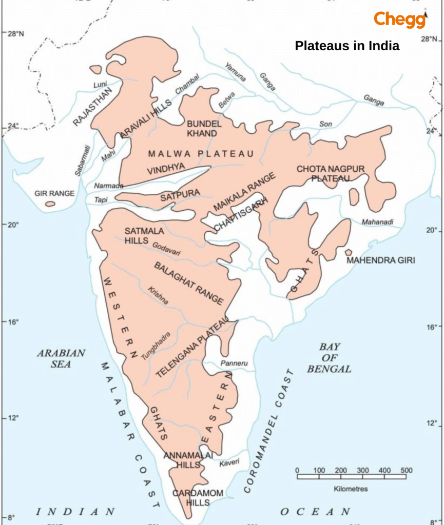
The 7 main plateaus in India are the Marwar Plateau, Central Highlands, Bundelkhand Plateau, Malwa Plateau, Baghelkhand Plateau, Chota Nagpur Plateau, and Meghalaya Plateau.
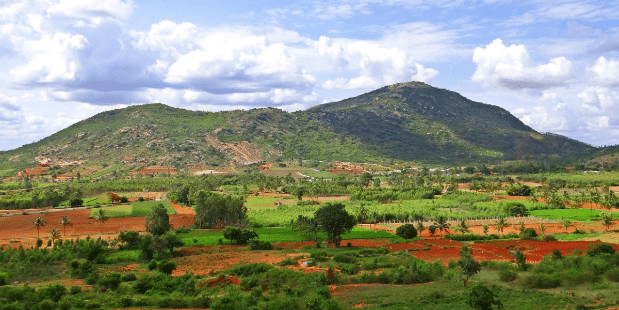
India hosts major plateaus like the vast Deccan and rugged Chotanagpur, shaping the nation’s climate, agriculture, and biodiversity with unique geological features.
Table of Contents
India is home to several important plateaus, including the Deccan Plateau, Chota Nagpur Plateau, and Malwa Plateau. These elevated landforms play a vital role in agriculture, mining, and climate regulation. The central plateaus in India include the Deccan Plateau, Marwar Plateau, Central Highland, Bundelkhand Upland, Malwa Plateau, Baghelkhand Plateau, Chota Nagpur Plateau, Meghalaya Plateau, and Maharashtra Plateau. This guide covers their key features, locations, and importance to India’s geography.
These plateaus are rich in minerals, making them crucial for mining activities. Their fertile soils also support extensive agriculture and are home to diverse ecosystems contributing to biodiversity. Understanding the formation and importance of plateaus helps us appreciate these unique landforms and their contributions to India’s geography and economy.
What is a Plateau?
A plateau is a flat-topped landform that rises sharply above the surrounding area. Due to its extensive, leveled surface, it is often referred to as a tableland. Plateaus in India are formed through various geological processes, including volcanic activity, tectonic movements, and erosion.
Volcanic activity involves repeated lava flows that build up over time, creating a flat, elevated surface. Tectonic movements occur when the Earth’s crust is pushed upward due to the collision or separation of tectonic plates, resulting in elevated landforms. Erosion, caused by wind, water, and ice, gradually wears away the surrounding land, leaving the higher land intact as a plateau. Plateaus in India are rich in minerals, making them crucial for mining activities.
How are Plateaus Formed?
Plateaus are created through a variety of geological processes. One typical method is tectonic uplift, in which the Earth’s crust is pushed upward, resulting in elevated landforms. Plateaus can also be generated by volcanic activity, in which successive lava eruptions accumulate over time, resulting in a level or gradually sloping surface. Erosion and weathering also contribute to the formation of plateaus. The surrounding lands are steadily eroded by wind, water, and ice, but the elevated plateau remains largely intact.
Glacial Activity: During the ice ages, glaciers covered vast areas; as they melted away, they left behind flat terrain, which formed an interglacial plateau.
Volcanic Activity: This happens when hot lava from a volcano flows out, spreads out, and cools down, creating a nice flat surface.
Erosion: Over time, the land gets gradually worn down by wind, water, or ice, which shapes it into flat and elevated areas.
Tectonic Movements: Movements in the Earth’s crust can lift land, resulting in a high, flat region known as a plateau.
Dissected by Rivers: Rivers and streams can carve deep valleys into elevated land, creating a dissected plateau.
Lava Flow: When lava pours out, cools, and solidifies, it forms a flat and elevated landscape.
Types of Plateaus in India
India has several breathtaking plateaus with unique geological features, climate, and cultural significance. These elevated landforms are crucial in shaping the country’s geography and supporting diverse ecosystems. From the vast Deccan Plateau to the rugged Ladakh Plateau, there are seven excellent types of plateaus in India that showcase the nation’s natural beauty and rich heritage.
1. Deccan Plateau
The Deccan Plateau is the most extensive plateau in India, covering much of central and southern India. It spans several states, including Maharashtra, Karnataka, Telangana, Andhra Pradesh, and Tamil Nadu. Formed by ancient volcanic activity, the Deccan Plateau is rich in minerals like coal, iron ore, and manganese.
Location: The Deccan Plateau spans a vast central and southern India.
States Covered: Maharashtra, Karnataka, Telangana, Andhra Pradesh, Tamil Nadu.
Formation: This plateau is volcanic, formed by ancient lava flows that solidified over time. The lava flows created a large, flat area above the surrounding regions.
Importance: The Deccan Plateau is incredibly rich in minerals such as coal, iron ore, and manganese, making it a crucial area for mining activities. The plateau’s fertile soil supports extensive agriculture, including cotton, sugarcane, and rice. Additionally, the region has diverse forests that provide valuable timber and support wildlife.
2. Malwa Plateau
The Malwa Plateau is in central India, primarily in Madhya Pradesh and parts of Rajasthan. It was formed by ancient lava flows and is known for its fertile black soil, ideal for growing cotton.
Location: The Malwa Plateau is situated in central India.
States Covered: Madhya Pradesh, Rajasthan.
Formation: The Malwa Plateau is volcanic, formed by ancient lava flows. The lava flows created fertile black soil, which is ideal for agriculture.
Importance: The Malwa Plateau is known for its black soil, particularly suitable for growing cotton. The region is also famous for its historical sites, such as Mandu, which attract tourists worldwide. The plateau’s agricultural productivity and historical significance make it an important area in India.
3. Chota Nagpur Plateau
The Chota Nagpur Plateau is in eastern India, spanning Jharkhand, Odisha, Chhattisgarh, and West Bengal. Formed through tectonic activity, it is rich in minerals such as coal, iron ore, and mica, making it a major mining hub.
Location: This plateau is located in eastern India.
States Covered: Jharkhand, Odisha, Chhattisgarh, West Bengal.
Formation: The Chota Nagpur Plateau was formed through tectonic activity, where movements in the Earth’s crust uplifted the land.
Importance: Rich in minerals like coal, iron, and mica, the Chota Nagpur Plateau is a major mining hub. The region’s mineral wealth supports numerous industries, including steel production and coal mining. The plateau’s rugged terrain and dense forests also provide habitats for various wildlife species.
4. Bundelkhand Plateau
The Bundelkhand Plateau is located in northern-central India, covering parts of Uttar Pradesh and Madhya Pradesh. It was formed through tectonic uplift and features rugged terrain and rocky outcrops.
Location: The Bundelkhand Plateau is found in northern-central India.
States Covered: Uttar Pradesh, Madhya Pradesh.
Formation: Formed through tectonic upliftment, the Bundelkhand Plateau features rocky terrain and rugged landscapes.
Importance: This plateau is rich in granite and sandstone, making it significant for construction materials. The region is also historically significant, with many ancient forts, temples, and monuments that reflect India’s rich cultural heritage. The plateau’s unique geological features and historical sites make it a fascinating area to explore.
5. Meghalaya Plateau
The Meghalaya Plateau is located in northeastern India, primarily in Meghalaya. It is part of the larger Shillong Plateau and is known for its scenic beauty, with rolling hills, deep valleys, and numerous waterfalls.
Location: The Meghalaya Plateau is located in northeastern India.
States Covered: Meghalaya.
Formation: Part of the larger Shillong Plateau, the Meghalaya Plateau was formed through tectonic upliftment and erosion.
Importance: Known for its heavy rainfall, the Meghalaya Plateau is home to some of the wettest places on Earth, such as Mawsynram and Cherrapunji. The region’s lush greenery and diverse flora and fauna make it a biodiversity hotspot. The plateau’s scenic beauty and unique climate attract tourists and researchers alike.
6. Kathiawar Plateau
The Kathiawar Plateau is located in western India, primarily in Gujarat. It is volcanic and rich in minerals such as limestone and bauxite. The plateau supports various industries, including cement production and aluminum manufacturing.
Location: The Kathiawar Plateau is situated in western India.
States Covered: Gujarat.
Formation: This plateau is volcanic and formed by ancient lava flows.
Importance: Rich in limestone and bauxite, the Kathiawar Plateau supports various industries, including cement production and aluminum manufacturing. The region is also home to the Gir National Park, the last refuge of the Asiatic lion. The plateau’s geological features and wildlife make it an important area for conservation and tourism.
7. Ladakh Plateau
The Ladakh Plateau is located in northern India, primarily in the union territories of Jammu and Kashmir and Ladakh. Formed through tectonic upliftment, it features high-altitude desert landscapes with stunning mountains, valleys, and lakes.
Location: The Ladakh Plateau is found in northern India.
States Covered: Jammu and Kashmir, Ladakh.
Formation: Formed through tectonic upliftment, the Ladakh Plateau features high-altitude desert landscapes.
Importance: This cold desert region is known for its stunning landscapes, including mountains, valleys, and lakes. The plateau is vital for tourism, attracting visitors with its unique cultural heritage and natural beauty. Additionally, Ladakh holds strategic significance for defense due to its location near international borders.
These plateaus in India showcase the country’s diverse geological features and rich natural resources. Understanding their formation and importance helps us appreciate the varied landscapes and their contributions to India’s economy and culture.
Features of Plateaus in India
Elevation: Averages between 600 and 900 meters above mean sea level.
Shape: Roughly triangular, with a broad southern base tapering to Kanyakumari.
Extent: The northern boundary stretches from Kutch via the Aravalis to Delhi, then follows the Yamuna and Ganga to the Rajmahal Hills and Delta.
Boundaries: Enclosed by the Aravali, Vindhya, Satpura, Bharmer, and Rajmahal Hills in the north, the Western Ghats in the west, and the Eastern Ghats in the east.
Area: Covers 16 lakh sq. km, constituting nearly half of India’s total area.
Composition: Formed of ancient schists and Archaean rocks, creating a stable, minimally altered shield.
Slope: Predominantly slopes from west to east, directing most rivers (except Narmada and Tapi) to drain into the Bay of Bengal.
Lists of Plateaus in India with States
Here is the list of Plateaus in India with states:
Name
States
Deccan Plateau
Maharashtra, Telangana, Andhra Pradesh, Karnataka, Tamil Nadu
Chota Nagpur Plateau
Jharkhand, Odisha, West Bengal, Chhattisgarh
Malwa Plateau
Madhya Pradesh, Rajasthan
Karnataka Plateau
Karnataka
Meghalaya Plateau
Meghalaya, Assam, parts of Nagaland
Bundelkhand Plateau
Uttar Pradesh, Madhya Pradesh
Marwar Plateau
Rajasthan
Major Hill Ranges of Peninsular India
Framing the Peninsular Plateau, these ancient hill ranges are more than just scenic landmarks. They are climatic barriers, watersheds for major rivers, and repositories of immense biodiversity and mineral wealth, fundamentally shaping the life and economy of the region.
1. The Aravalli Range
Location: Extends approximately 800 km from Delhi to Palanpur in Gujarat.
Formation: Remnants of one of Earth’s oldest fold mountain systems.
Key Features: Average elevation of 400-600 m. Guru Shikhar (1,722 m) on Mount Abu is the highest peak.
Significance: Acts as a crucial check against the Thar Desert’s expansion and is rich in minerals like copper and marble.
2. The Vindhyan Range
Location: Runs parallel to the Narmada Valley for about 1,200 km, from Gujarat to Bihar.
Formation: A block mountain system formed by cracks in the Earth’s crust.
Key Features: Composed of ancient sedimentary rocks, with an average elevation of 300-650 m. Its subdivisions include the Kaimur and Bharner Hills.
Significance: Has historically been a major cultural and geographical divide between North and South India.
3. The Satpura Range
Location: A 900 km long range running east-west between the Narmada and Tapi rivers.
Formation: A series of seven block mountains (‘Satpura’ means ‘seven folds’).
Key Features: Notable peaks include Dhupgarh (1,350 m), the highest point in Central India. Drained by the Narmada and Tapi rivers.
Significance: Home to the Pachmarhi Biosphere Reserve and a crucial watershed for central India.
4. The Western Ghats (Sahyadris)
Location: Runs parallel to the western coast from the Tapi Valley to Kanyakumari.
Key Features: A continuous, steep escarpment on the west, sloping gently eastward. It is divided into Northern, Central, and Southern sections.
Northern: Features peaks like Kalsubai (1,646 m) and important passes like Thal Ghat.
Central: Includes high peaks like Doddabetta (2,637 m) in the Nilgiris.
Southern: Dominated by Anai Mudi (2,695 m), the highest peak in peninsular India, which gives rise to the Anaimalai, Palni, and Cardamom Hills.
Significance: A UNESCO World Heritage Site and global biodiversity hotspot that intercepts the monsoon, causing heavy rainfall on the windward side.
5. The Eastern Ghats
Location: A discontinuous series of ranges along the eastern coast, from Odisha to Tamil Nadu.
Key Features: Highly eroded and fragmented, unlike the continuous Western Ghats. Key sections include the Maliya and Madugula Ranges in the north, and the Nallamala, Javadi, and Shevroy Hills in the south. Arma Konda (1,680 m) is the highest peak.
Significance: Rich in mineral resources like bauxite and iron ore. These hills merge with the Western Ghats at the Nilgiri Hills.
By making these changes, you transform a good factual section into a compelling and authoritative piece that answers all of the reader’s potential questions.
Significance of the Peninsular Plateau
Abundance of Minerals: Rich deposits underpin robust industrial growth and economic progress.
Fertile Black Soils: Nutrient-dense soils significantly enhance agricultural output, especially for cotton.
Dense Forests: Expansive forests serve as crucial carbon sinks while preserving diverse ecosystems.
Natural Habitat: Varied landscapes nurture unique habitats that support endemic species.
River Flowing Through the Plateau: Vital rivers provide essential water for irrigation, consumption, and hydropower.
Hill Resorts: Scenic hill resorts boost tourism and promote sustainable economic opportunities.
Importance of Plateaus in India
India’s plateaus are vital to the nation’s geography, economy, and ecology. Their key contributions are:
Mineral Wealth: Plateaus like the Chota Nagpur are rich in essential minerals such as coal, iron ore, and mica, forming the backbone of India’s mining and industrial sectors.
Agricultural Hub: The fertile soils of plateaus, especially the black soil of the Malwa Plateau, support extensive agriculture, including cash crops like cotton, and provide livelihoods for millions.
Biodiversity Reserves: These regions host diverse ecosystems and crucial wildlife reserves, such as Gir Forest (home to the Asiatic lion) and Satpura National Park, preserving India’s unique natural heritage.
Water Sources: Major rivers like the Godavari and Krishna originate from plateaus, providing vital water for irrigation, drinking, and hydropower to vast regions of the country.
Tourism & Culture: Plateaus hold significant historical and cultural sites, including Hampi and Ujjain. Their scenic beauty, waterfalls, and caves attract tourism, boosting local economies and preserving heritage.
In short, plateaus are indispensable to India’s development, providing critical resources, supporting livelihoods, and sustaining ecological balance.
Conclusion
Plateaus in India play a crucial role in the nation’s economy and geography. They offer rich mineral deposits such as coal and iron on the Chota Nagpur Plateau and fertile soils, like the black soil of the Malwa Plateau, ideal for cotton cultivation. Additionally, these flatlands provide grazing lands and support diverse ecosystems, including wildlife reserves like Gir Forest and Satpura National Park. The expansive Deccan Plateau, the most extensive plateau in India, further enriches the landscape with its vast stretch and abundant natural resources. With significant historical and cultural sites such as Hampi and Ujjain, plateaus also boost tourism and local livelihoods.
The Peninsular Plateau, formed from the drifting of the Gondwana land, is India’s oldest landmass. Broad valleys and rounded hills characterize it.
Which Plateau is Most Famous in India?
The Deccan Plateau in southern India, situated between the Western and Eastern Ghats, is the country’s most renowned plateau. It encompasses the peninsular region south of the Narmada River and is bordered by the Satpura and Vindhya Ranges to the north.
What is a plateau in geography?
A plateau is a level stretch of raised land with at least one side that rises sharply above the surrounding area.
What are the 7 plateaus in India?
There are a total of 7 Platues in India: 1. Marwar Plateau 2. Central Highland 3. Bundelkhand Upland 4. Malwa Plateau 5. Baghelkhand 6. Chota Nagpur Plateau 7. Meghalaya Plateau 8. Deccan Plateau (This is often referred to as the Maharashtra Plateau as well)
What are the most famous plateaus?
The Tibetan Plateau is the world’s highest, largest, and most famous. It stretches through Tibet, China, and India in South-Central Asia.
Which is the smallest plateau in India?
The Sigur Plateau in Tamil Nadu is considered one of the smallest plateaus in India
Which is the biggest plateau in India?
The biggest plateau in India is the Deccan Plateau. Covering an area of about 1.9 million square kilometers, it extends across eight states, including Maharashtra, Telangana, Andhra Pradesh, Karnataka, and Tamil Nadu. Known for its rich mineral resources and diverse landscapes, the Deccan Plateau plays a vital role in India’s agriculture, biodiversity, and history.
What are the two famous plateaus?
The two most famous plateaus in India are the Deccan Plateau and the Chota Nagpur Plateau. The Deccan Plateau is the largest in India, known for its volcanic origins and black soil, while the Chota Nagpur Plateau is renowned as a mineral-rich region, often called the “Ruhr of India” for its vast coal and iron ore deposits.
Authored by, Muskan Gupta Content Curator
Muskan believes learning should feel like an adventure, not a chore. With years of experience in content creation and strategy, she specializes in educational topics, online earning opportunities, and general knowledge. She enjoys sharing her insights through blogs and articles that inform and inspire her readers. When she’s not writing, you’ll likely find her hopping between bookstores and bakeries, always in search of her next favorite read or treat.