A Standard Meridian of India is an imaginary line from the North to the South Pole. It helps measure locations on Earth, showing the distance east or west of the Prime Meridian, which is at zero degrees. Meridians are part of the global coordinate system and are used to define time zones and help with navigation.
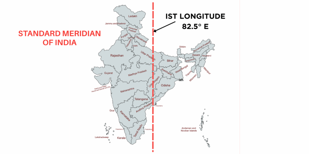
The Standard Meridian of India is 82°30’E (82.5°E), passing through Mirzapur, Uttar Pradesh. It sets Indian Standard Time (IST) and determines the official time for the entire country.
Which is the Standard Meridian of India?
The Standard Meridian of India is 82.5° East and passes through Mirzapur in Uttar Pradesh. This meridian is important for establishing Indian Standard Time (IST), which is 5 hours and 30 minutes ahead of Greenwich Mean Time (GMT). Using this specific meridian ensures uniformity and consistency in timekeeping throughout India. Since the country covers several time zones, adopting one standard time based on this meridian helps align daily activities nationwide, including business operations and transportation schedules.
Significance of the Standard Meridian Of India
The reference point for India’s standard time is the Standard Meridian, which passes through Mirzapur in Uttar Pradesh at a longitude of 82°30’E. Standard time is the synchronization of clocks within a particular geographical region to a single standard time instead of using solar time or a locally chosen meridian (longitude) to produce a local mean time standard.
Local times vary among different locations. In India, the local times of Dwarka in Gujarat and Dibrugarh in Assam are approximately one hour and forty-five minutes apart. A country must establish its standard time based on the local time of its central meridian.
History of IST
In India, most towns followed their local time until the 1850s, when people built railroads. The requirement for a single time zone became evident as railroads expanded. Cities like the capitals of the two largest British Indian Presidencies, Bombay (then known as Bombay) and Calcutta (then known as Kolkata), were instrumental in this transition. Neighboring regions gradually adopted the standard time of these cities.
The telegraph was essential for keeping clocks synchronized during the 1800s. For instance, railroads relied on time signals from their headquarters to set their clocks daily. The International Meridian Conference in Washington, D.C., established global time zones in 1884. The authorities designated India with two time zones: the 75° E meridian for Bombay and the 90th east meridian for Calcutta. They set the time in Bombay to be four hours and fifty-one minutes ahead of GMT and the time in Calcutta to be five, thirty, and twenty-one seconds ahead.
By the late 1880s, numerous railroad companies adopted the Madras time, sometimes called “Railway time,” as a compromise between the two zones. The British colonial government set Port Blair’s time for the Andaman and Nicobar Islands 49 minutes and 51 seconds ahead of Madras time.
British India formally adopted a single standard time zone in 1905, setting the central meridian of India at 82.5° E longitude, east of Allahabad. On January 1, 1906, this new time zone also included Sri Lanka, then called Ceylon. Until 1948, people recognized Calcutta time as a separate time zone.
Importance of the Standard Meridian of India
The Standard Meridian of India ensures time uniformity, aids navigation, strengthens economic activities, and fosters seamless national and international coordination. The standard meridian of India, located at 82.5° East longitude, plays a crucial role in various aspects of the country’s functioning. Here are some key points highlighting its importance:

- Time Standardization:
- Ensures uniform time across India, facilitating coordination and scheduling of activities.
- Aligns India with global time zones, enhancing communication and connectivity.
- Navigation Aid:
- Assists mariners and aviators in calculating positions and setting time zones for safe and efficient travel.
- Global Time Zone Framework:
- India’s standard meridian (82.5° E) aligns with the global system of 24 time zones at 15° intervals from the Prime Meridian (0° longitude at Greenwich, London).
- Location of the Standard Meridian:
- The 82.5° E longitude passes through Mirzapur, Uttar Pradesh, and other states, such as Madhya Pradesh, Chhattisgarh, Odisha, and Andhra Pradesh.
- It forms the basis of Indian Standard Time (IST), UTC +5:30.
- Historical Significance:
- Played a key role during the British era in streamlining railway schedules.
- Economic Benefits:
- Simplifies business operations by providing a uniform time zone across India.
- Enhances trade and commerce by eliminating confusion caused by different local times.
- Supports international business interactions with efficient communication and coordination.
- National Coordination:
- Facilitates the smooth operation of government, education, transport, and other systems on a standard time reference.
The Standard Meridian: A Global Perspective
A standard meridian is essential for setting time zones and keeping time consistent worldwide. Here’s a global look at standard meridians, their importance, and how they work in different contexts. So far, we’ve talked about the standard meridian in India. Now, let’s explore the standard meridians in other countries globally.
1. Paris Meridian (France)
Before adopting the Greenwich Meridian, people used the Paris Meridian (2°20’14.025″ E) as the prime meridian, and it played a pivotal role in early longitudinal measurements.
2. Washington Meridian (USA)
The Washington Meridian (77°02’11.562″ W) was one of the several historic prime meridians of the United States. The U.S. used it in the 19th century. Coast.

3. Antwerp Meridian (Belgium)
Belgium established its meridian (4°24’43.43″ E) as a reference point for longitude measurements.
4. Pulkovo Meridian (Russia)
Russian astronomy used the Pulkovo Meridian (30°19’42.09″ E) as the prime meridian.
The comparative analysis of different meridians worldwide demonstrates that some countries, like the USA and Belgium, historically had their prime meridians for local mapping and navigation. The Greenwich Meridian eventually replaced them for global coordination.

Locating the Standard Meridian of India on Map
Countries choose their Standard Meridian on multiples of 7 degrees and 30 minutes or 15 degrees to enable time calculation in half-hour increments (7.5 X 4 = 30 min) and one hour (15 X 4 = 60 min). This is why the 82 degrees 30 minutes east longitude line is designated as the Indian Standard Time (IST), which is 5 hours and 30 minutes ahead of Greenwich Mean Time (GMT). You can draw a vertical line at the 82.5° E mark using a physical map to visualize the Standard Meridian. You can often input the coordinates on digital maps to see the exact line.
- The selection of the central meridian helps minimize the difference in local time across the nation, making it more convenient for both the government and the general public.
- Historically, India established and used the 82.30 degrees east meridian as a reference point for navigation and mapping. Using an accepted system simplifies the transition to a standardized time system.
- The 82.30-degree standard meridian of India balances the time zone across the country. It allows a fair distribution of daylight hours and minimizes disruptions in daily life, especially in regions near the boundary.
Visual Representation of the Standard Meridian
The Standard meridian of India on the map passes through Mirzapur, Uttar Pradesh (Village Kharavada) (82 degrees 30 min east) and Champa, Chhattisgarh (82 degrees 29 min east). This meridian is a reference point for standardizing time zones across the country.
The Standard Meridian of India plays a crucial role in defining the east-west position of any location in the country. To accomplish this, measure the angular distance of a point east or west of the Standard Meridian. In practical terms, coordinates are vital for accurately pinpointing and locating specific places within India while navigating maps. On a typical world map, the 82.5° E line will be shown as a vertical line running from the North to the South Pole, intersecting various geographical features and states in India.
The coordinates are the values that specify the location on the Earth’s surface and are crucial for navigation and mapping. It further comprises two components :
(A). Latitude – Degrees express the range from -900 (South Pole) to +900 (North Pole). The equator is located at 0 degrees latitude, and the lines run horizontally, also known as parallels.
(B). Longitude—It determines how east or west the location is from the prime meridian and ranges from -1800 to +1800. Meridians run vertically, and people also know them as meridians.

Which states does the Standard Meridian of India pass through?
The standard meridian of India passes through the following states and cities:
- Uttar Pradesh – A substantial state region, including Lucknow’s capital city, is close to the 82.5 degrees east meridian.
- Madhya Pradesh – The standard meridian of India passes through the northern part of Madhya Pradesh, impacting cities like Bhopal and Gwalior.
- Chhattisgarh—The eastern regions of the state, comprising the hilly areas, are influenced by the Standard Meridian.
- Orissa – A significant portion of the state, including cities like Bhubaneswar and Cuttack, is touched by the 82.50 east meridian.
- Andhra Pradesh – The state’s southeastern part is mainly affected by the Standard Meridian.
Standard Meridian vs. Prime Meridian: Key Distinctions
Understanding the concept of the Standard Meridian and the Prime Meridian is pivotal for accurate global positioning and navigation.
| Prime Meridian | Standard Meridian | |
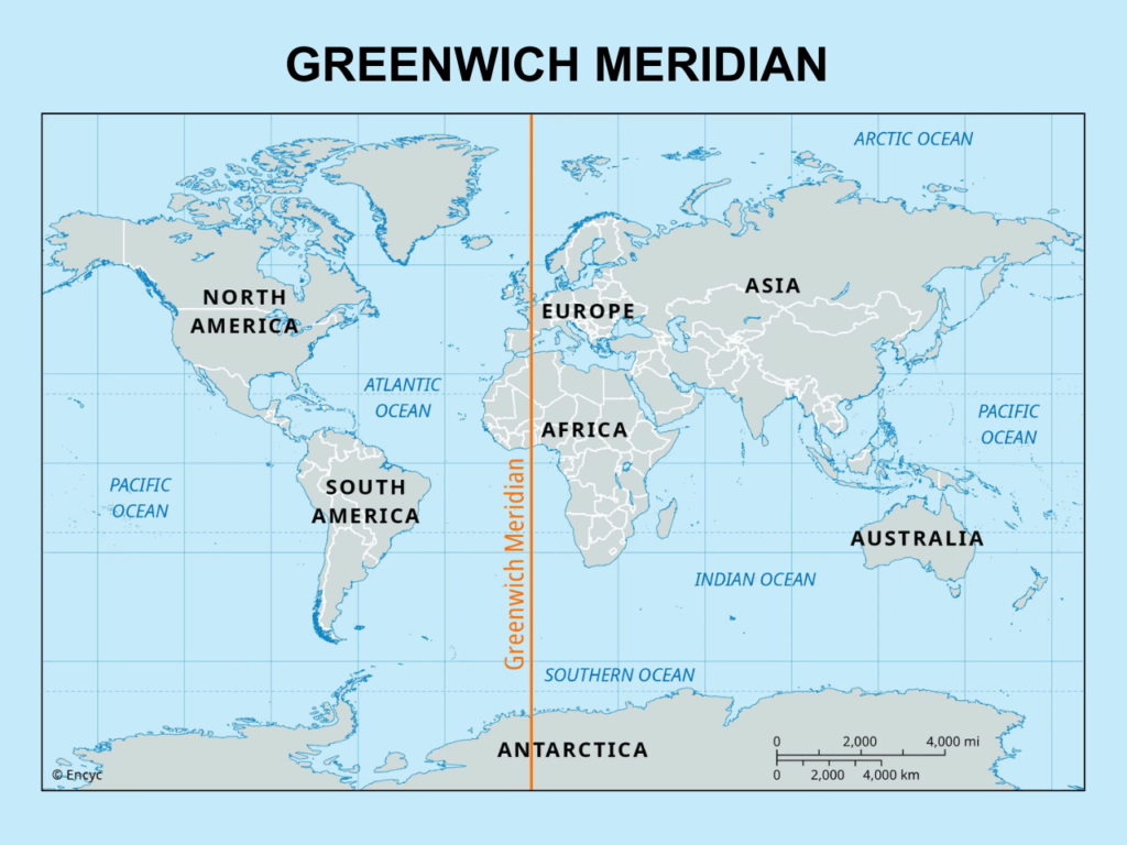
| Definition | The Prime Meridian plays a significant role in establishing UTC, the world’s standard time for timekeeping. | It is an imaginary line extending from the North to the South Pole and passing through Greenwich, England. The Prime Meridian is a 0-degree longitude and reference point from which all other longitudes are measured. |
| Role in Timekeeping | Standard Meridian establishes the local time within a specific region. This ensures that people from different areas of the country experience daylight and darkness roughly simultaneously. | It is an imaginary line extending from the North to the South Pole and passing through Greenwich, England. The Prime Meridian is a 0-degree longitude and is a reference point from which all other longitudes are measured. |
| Geographical Significance | The Greenwich PM’s position has led to the creation of GMT and GMST, which are used in astronomical and navigation calculations. | It helps countries efficiently manage their time zones and synchronize activities like transportation, communication, and border functionalities. |
Impact of Standard Meridian on Indian Culture
The IST sets the time zone for the entire country. It synchronizes our daily routine and affects the auspicious moments for celebrating various rituals and festivals in India. The Standard Meridian of India helps determine the precise timing of events, aligning them with the Indian Standard Time.
Beyond Borders and Boundaries
Let’s explore the influence of standard meridians on international relations and diplomacy-
- Standard Meridians have a direct impact on global commerce. Efficient business operations within a country depend on internal coordination. Misaligned time zones can cause communication, transportation, and shipping delays, impacting international trade.
- It also plays a vital role in international agreements. In 1884, the International Meridian Conference adopted the Greenwich Meridian as the prime meridian, establishing it as a reference point for navigation and trade.
- The standard meridian greatly influences the global stock market, yet its role is often underappreciated. Trading hours revolve around the standard meridian, and decisions made during these hours affect the nation’s financial market.
Thus, a thoughtful consideration of the standard meridian can lead to efficient and effective global interaction and communication.
The Bottom Line
The Standard Meridian of India is a key part of the nation’s infrastructure. It plays a vital role in daily life, the economy, and technology. Having a single time-keeping reference point gives the country a uniform time zone. This consistency helps coordinate everything from business operations to government activities. Indian Standard Time (IST), which is based on this meridian, syncs up transportation schedules, communications, and broadcast timings. This ensures smooth operations in a large and diverse country like India.
Additionally, it makes geographic coordination and communication simpler worldwide. It is a crucial reference for global navigation systems, mapping, and positioning, which benefits domestic and international travel. This meridian helps accurately calculate distances and routes for air and sea travel. Its compatibility with satellite technology has dramatically improved communication systems. With its close ties to technology, economic growth, and cultural connections, India’s Standard Meridian is vital for linking the nation with the world and supporting India’s rising influence on the global stage.
Conclusion:
The Indian Standard Meridian is vital in various areas, including timekeeping, navigation, geographical referencing, international coordination, and economic activities. It is a key reference for setting time zones, identifying geographical locations, and designing accurate maps. Understanding the significance of the Standard Meridian of India helps us recognize its role in promoting efficiency, order, and smooth operations in both local and global settings, making it vital for modern life.
Frequently Asked Questions(FAQs)
What is the Greenwich Meridian of India?
India’s standard meridian is 82.5°E from the Greenwich Meridian, chosen to maintain a uniform time across the country.
The Standard Meridian of India passes through which states?
In India, the standard meridian crosses through Uttar Pradesh, Odisha, Andhra Pradesh, Madhya Pradesh, and Chhattisgarh.
When was the standard time in Calcutta discontinued and separated?
The standard time in Calcutta (Calcutta Time) was discontinued and separated on 1 January 1906. It was replaced by the Indian Standard Time (IST) based on the 82.5° E longitude passing through Mirzapur, Uttar Pradesh.
With so many different time zones and longitudes, why is Mirzapur considered India’s Standard Meridian?
India has many different time zones, so treating everyone in the country as though they are all on the same Standard Meridian will be highly confusing. The combination of the shared work schedule, the flight, and the train will cause a lot of confusion, and fewer people in India will come to understand the concept of multiple time zones.
Why is 82.30 considered India’s standard meridian?
In comparison to Gujarat, Arunachal Pradesh experiences a two-hour earlier sunrise. To prevent confusion and establish a standard time for reference, authorities have observed a 2-hour time difference between Gujarat and Arunachal Pradesh. The standard time for the entire nation is 82.30 degrees Eastern Longitude.
Why do we consider Mirzapur as the standard meridian?
Indian Standard Time is determined based on the approximate location of 82.5°E longitude in Mirzapur, Uttar Pradesh. It was selected because it is at the intersection of the nation’s eastern and western longitudinal extremities.
What is the standard meridian of India?
The Standard Meridian of India is 82°30’E (82.5°E), passing through Mirzapur, Uttar Pradesh. It sets Indian Standard Time (IST) and determines the official time for the entire country.
What is the prime meridian of India?
The prime meridian of India is the Standard Meridian, located at 82°30′ East longitude. It passes near Mirzapur in Uttar Pradesh and is used to set Indian Standard Time (IST).
What is standard meridian?
The standard meridian is a specific line of longitude a country selects as the basis for its standard time. It helps ensure a uniform time across the region.