Longest Coastline in India
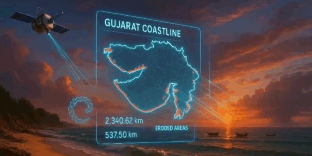
India has a total coastline of 7,516 km, stretching along the Arabian Sea and the Bay of Bengal, making it one of the most diverse and culturally rich coastal regions in the world. As of 2024, Gujarat has the longest coastline in India, measuring 2,340 km, mainly along the Kathiawar Peninsula. It is followed by Tamil Nadu with 1,068 km, Andhra Pradesh with 1,053 km, and West Bengal with 721 km.
Gujarat’s coast, often referred to as the “Coastal Marvel of India,” is known for its scenic beaches, historical ports, and vibrant marine biodiversity. India’s coastal states, including Goa, Tamil Nadu, and Kerala, are rich in heritage featuring colonial influences, ancient temples, and vital trade hubs like Mumbai, Chennai, and Kolkata. These coastal areas also support unique ecosystems, providing nesting grounds for migratory birds and endangered sea turtles.
List of Longest Coastlines in India
| S. No. | State | Length (km) |
|---|---|---|
| 1 | Gujarat | 1,600 |
| 2 | Tamil Nadu | 1,076 |
| 3 | Andhra Pradesh | 975 |
| 4 | Maharashtra | 720 |
| 5 | Kerala | 580 |
| 6 | Odisha | 485 |
| 7 | Karnataka | 320 |
| 8 | West Bengal | 210 |
| 9 | Goa | 160 |
Top 10 Longest Coastline in India
Let’s dive into the coastal states of India outlined by the Indian coastline and how the coastline influences the identities of these states.
Gujarat: Longest Coastline in India
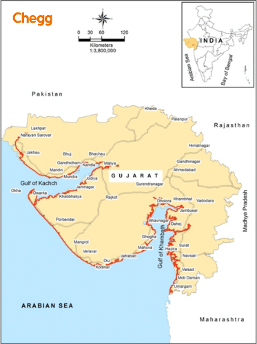
Gujarat occupies 24% of the country’s shoreline, making it the longest coastline in India. Reaching the Arabian Sea from the Kathiawar region serves as a starting point for visits to captivating beaches such as Nagao, Dwarka, and others. There are 41 seaports in Gujarat in total, including 1 major, 29 minor, and 11 intermediate ones. The islands of the Gulf of Kutch, including the Jamnagar Coast and Marine National Park, are well known.
Tamil Nadu: 2nd Longest Coastline in India
Located in the Coastal Andhra region, Tamil Nadu is the Second longest coastline in India. This coastline, which stretches 973 km, runs along the Coromandel Coast between the Eastern Ghats and the Bay of Bengal. Because of the Krishna River, the Godavari Delta, and the Penna River, this coastline has abundant agricultural land. Twelve significant ports are along this coastline.
Andhra Pradesh: 3rd Longest Coastline in India
Located in the Coastal Andhra region, Andhra Pradesh is the third longest coastline in India. This coastline, which stretches 973 km, runs along the Coromandel Coast between the Eastern Ghats and the Bay of Bengal. Because of the Krishna River, the Godavari Delta, and the Penna River, this coastline has abundant agricultural land. Twelve significant ports are along this coastline.
Maharashtra: 4th Longest Coastline in India
The Konkan Coast, or 720 km of coastline in Maharashtra, is the fourth longest coastline in India. It makes up 10% of the coastline in India. Its borders are the Arabian Sea to the west, the Daman Ganga River to the north, the Gangavalli River to the south, and the Western Ghats mountain range to the east. 53 ports in total 2 major and 51 minor or intermediate are present. The Konkan coastline, which is home to numerous beaches, serves as a perfect entry point for residents of Pune and Mumbai.
Kerala: 5th Longest Coastline in India
Kerala’s Malabar Coast, which stretches 580 km, is home to India’s fifth-longest coastline in India. It stretches from the southwest corner of Maharashtra through Goa, Karnataka, Kerala, and Kanyakumari. To the west and east, it is bounded by the Arabian Sea and the Western Ghats. The Malabar Coast is well-known for its stunning landscapes, beaches, brackish water lakes, tea and coffee plantations, and more. There are thirteen main ports there.
Odisha: 6th Longest Coastline in India
Odisha, also known as the Utkal Plains, is a state in India that borders the Bay of Bengal with a 485 km coastline that is dotted with complex deltas. It boasts seaside beaches like Chandipur, Gopalpur, and Gahirmatha. The second-largest mangrove ecosystem is one of its treasures. It also includes Chilika Lake, the nation’s coastal lagoon.
Karnataka: 7th Longest Coastline in India
The 320-kilometer Karnataka Coastline is also referred to as Kanara. While Gujarat boasts the longest coastline in India, Karnataka’s coastline holds its own with incredible natural beauty and maritime significance. Its borders meet the Arabian Sea in the west, the Kerala Plains in the south, the Konkan in the north, and the Western Ghats in the east. It has some tourist attractions, including St. Mary’s Island Beach and Maravanthe. Its three districts are Udupi, Dakshina, and Uttara Kannada as well as its ten major ports and two minor/intermediate ports add to its maritime importance.
West Bengal: 8th Longest Coastline in India
The districts of Purba Medinipur and South 24 Parganas contain West Bengal’s coastal plain. The world’s largest mangrove forest, the Sundarbans delta, is home to a variety of wildlife, most notably the magnificent Royal Bengal tiger. West Bengal’s economy is based primarily on agriculture, with rice, potatoes, jute, sugarcane, and wheat being its main crops. The state’s maritime significance is increased by the presence of a single major port.
Goa: 9th Longest Coastline in India
Situated on the southwest coast of India, Goa has one of the nation’s smallest coastline in India, but it is undoubtedly one of the most captivating. While Gujarat boasts the longest coastline in India, Goa’s coastline, though shorter, offers some of the most beautiful and pristine beaches in the world. Karnataka borders it to the east and south, Maharashtra to the north, and the Arabian Sea hugs its western edge. Rich growth is supported by the ferric-aluminum oxide-rich reddish soil of Goa. Rich in humus and minerals, it supports agriculture, especially on riverbanks. It retains its maritime importance with one major port and five minor ports.
Andaman & Nicobar Islands (UT): Coastline
The Andaman & Nicobar Islands, a Union Territory of India located in the Bay of Bengal, boasts the longest coastline among all Indian Union Territories, stretching approximately 1,962 kilometers. This extensive coastline is spread across 572 islands, of which only around 38 are inhabited. The territory is divided into two main groups: the Andaman Islands in the north and the Nicobar Islands in the south. The coastline is known for its pristine beaches, coral reefs, mangrove forests, and rich marine biodiversity
Significance of Coastal States of India
India’s coastal states are crucial for the reasons listed below:
The fishing sector: For many people in our nation, fishing is their primary source of income. Moreover, seafood constitutes a beneficial and healthful portion of their diet, with approximately 30% of all landings coming from India’s combined commercial ocean net.
Travel & Tourism: With its numerous islands and extensive coastline, India is a popular destination. In terms of beach tourism, it has achieved remarkable success in Andaman and Goa, where beach tourism is a major economic activity.
Transport: The development of various economic sectors depends on the use of Indian water bodies for logistics and transportation.
Tidal energy: You can use the power produced by the regular rising and falling of ocean tides as a result of the sun, moon, or earth’s gravitational pull to create electricity. Given that it is a renewable energy source, tidal energy may end up being a necessary power source shortly.
Ocean minerals: It is possible to transport coal, natural gas, and oil beneath the surface. Seawater also contains a variety of minerals, the most common of which is salt. Mineral resources abound in India, including garnet, rutile, ilmenite, zircon, sillimanite, and monazite.
Eastern Coastal States in India
- Odisha: located in eastern India Odisha is well-known for its temples, buildings, and sites like the Konark Sun Temple and the Puri Jagannath Temple.
- West Bengal: Known for its rich literary, historical, and cultural legacy, the West Bengal region of eastern India is bordered to the east by Bangladesh.
- Tamil Nadu: Southeast Asian coastal state, home to Chennai, a significant hub for education, business, and culture.
- Andhra Pradesh: The beautiful natural surroundings and rich cultural legacy of the Southeast Indian coastal state have made it renowned.
- Andaman & Nicobar (Islands): a collection of islands known for their lush forests and stunning scenery that are situated in the Bay of Bengal, a Union Territory of India.
- Puducherry: Union Territory, a well-liked tourist destination in southeast India, is noted for its beaches, cultural legacy, and French colonial architecture.
Western Coastal States in India
- Gujarat: Ahmedabad, the largest city with a rich cultural heritage, is well-known for its textile industries and commercial hubs.
- Western Coastal Plains: A 50 km stretch in western India that runs between the Arabian Sea and the Western Ghat mountains.
- Goa: The capital of India’s smallest western coastal state, Panaji, has colonial architecture and a rich history. The state has beautiful beaches, including Calangute, Anjuna, and Baga.
- Maharashtra: Mumbai, the capital, is a significant cultural and economic hub and has beautiful beaches like Juhu, Alibaug, and Ganapatipule.
Which State has the Longest Coastline in India?
You might be curious to know which state has the longest coastline in India. The answer is Gujrat. The longest coastline state in India covering this state extends over 1600 Kilometers. This vibrant state has a coastline blending geographical, geological, and ecological fascinating features.
- Geographically, the coastline is composed of sandy beaches, rugged cliffs, and bustling ports.
- Gujrat is home to geological treasures like the famous fossil park of Kutch, which has remains from prehistoric marine life (million years ago).
- The coastline has various habitats of flora and fauna.
- The Marine National Park near Jamnagar, Gujrat, has coral reefs, making this park a marine biodiversity hotspot.
- Along this coastline of Gujrat, we can see Dwarka, the city of Lord Krishna, acting as a spiritual beacon.
- The port city of Surat, known for its textile industry and diamond cutting, gives an economic advantage to this coastline. All these factors make Gujrat the state with the longest coastline.
Longest Coastline in India Map
The Coastal Areas of India
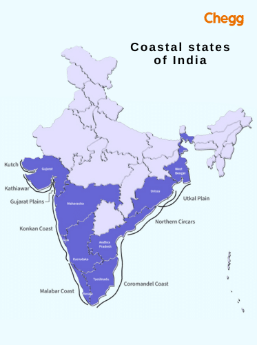
The length of the Indian coastline stretches over 7516.6 Kilometers. It is an interesting line where the land meets the sea. This interface between land and water is important for India’s identity, ecology, and economy. The table lists the major coastal states of India and regions along the Indian coastline.
| Coastal Regions | States/UTs |
| Western Coast | Gujrat, Maharashtra, Goa, Karnataka, and Kerala. |
| Konkan Coast (sub region of western coast) | Stretching from southern Maharashtra through Goa to Karnataka. |
| Malabar Coast (sub region of western coast) | Kerala |
| Eastern Coast | West Bengal, Odisha, Andhra Pradesh, and Tamil Nadu |
| Coarmondel Coast (sub region of eastern coast) | Tamil Nadu and Parts of Andhra Pradesh |
| Andaman and Nicobar Island | Located in the Bay of Bengal |
| Lakshadweep Island | Arabian Sea |
| Daman & Diu | Puducherry |
The coastal area of India appears as a transition zone in which the land gives way to the vast expanse of the sea. These zones help in storm surges and soil erosion and secure the coastal communities and infrastructure.
The Coral reefs are a habitat for various fish species and crabs. The mangrove forests give a nurturing breeding spot for sea turtles to lay their eggs. The coastal areas like Mumbai and Chennai in India play an important role in trading and international exchange.
India’s Largest Coastline
The longest coastline in India covers a wide range of ecosystems and landscapes. India’s largest coastline is along the western coast and borders the Arabian Sea. It stretches for approximately 1,600 kilometers.
India is present along the tropical and subtropical zones of the Earth. It is close to the equator, which affects the coastal climate. There are many types of coastal ecosystems-
Coral reefs – Coral reefs are mostly present around the southeastern coast. They are home to marine life.
Sandy Shores – The coastline has sandy beaches that host flora and fauna, including habitat for migratory birds and nesting sites for turtles.
Mangrove – The mangrove forests serve as a nursery for various species. The Bengal tigers in the Sundarbans and the coral gardens of the Andaman and Nicobar Islands are the main areas where diversity can be seen.
The Longest coastline state of India is Gujrat. This coastline plays an important role in Gujrat’s opportunities and economy. The coastal regions of Gujrat are filled with rich heritage:
- India’s Independence holds great significance in the coastal part near Sabarmati Ashram.
- Art forms like Garba dance during Navratri and the mix of language and customs around the coastline diversify it.
- Maritime traditions followed in the ports such as Kandla and Mundra contribute to the economy of this state.
- Gujrat has been a center for trading and commerce for centuries.
- Gujrat’s coastal region has a range of delicious seafood dishes like fried fish and prawn curry.
Management of the longest coastline comes with challenges and opportunities. Soil erosion around the coastal part, industrial development, and wildlife harm are key concerns from an environmental conservation point of view. Conversely, this longest coastline in India offers great economic potential through its shipping and trading of goods and fishing industry.
Exploring the Coastal Region of India
Let’s embark upon a virtual journey along the longest coastline in India, where you will witness the beauty of India’s coastal state. Now, picture yourself surrounded by lush greenery and standing on beaches with dunes and clear waters. Around that scene, you will also see the richness of culture in the coastal region of India. You can also sometimes witness migratory birds and sea turtles in their birthing time. Some places which are a must-visit in these coastal regions are as follows-
- Iconic beaches of Gujrat
- Historic ports and Sabarmati Ashram in Gujrat
- Cultural Festival of Tamil Nadu
- Temples of Odisha region
- Ports of Mumbai
- Beaches of Goa
- Greenery and forests of Kerala
An amazing heritage of Indian coastal regions is their language, which you will surely get to explore at your next visit. Linguists categorize these languages into different groups based on the region.
For example,
- On the eastern and Coromandel coast, people speak Dravidian languages like Malayalam, Tamil, Tulu, and Kannada.
- Telugu is spoken in the southeastern coastal region.
- The western coastal region comprises people speaking Gujarati, Marathi, and Konkani.
The Length of the Indian Coastline
As we know, the coastline of India is a geographical marvel that extends along the Arabian Sea and the Bay of Bengal. If we measure the length of the Indian coastline, it is around 7516.6 Kilometers and 4671.8 miles. Of these, Gujarat boasts the longest coastline in India, with over 1,600 kilometers of shore. The coastline’s intricate beauty and diverse ecosystems make it a true natural wonder. The coastline paradox method is used to measure coastlines. This method involves the use of many scales of measurement. To capture finer and minute details, measurements are taken in two parts: first on a large scale, and then on a smaller scale.
The Survey of India agency is responsible for measuring the coastline. They use technologies like GIS (Geographic Information System) for measuring large-scale areas and satellite imagery for small-scale measurements, which take small pictures of small areas to measure them. Countries like Canada, Indonesia, and Russia have surpassed India’s coastline in length when compared.
Read More:-
- Longest River in the World– Discover Its Name, Length & More
- India’s Longest Bridge: A Symbol of Connectivity and Development
- Longest National Highway in India: 10 Stunning Highways You Must Explore
- Longest Train Route in India: 10 Epic Journeys You Must Experience
- Hirakud Dam: India’s Longest and World’s Lengthiest Dam
- 10 Incredible Longest Beach in the World
Embracing the Vastness and Diversity of India’s Coastline
It is not just a stretch of land but a marvelous wonder filled with culture. India’s coastal regions offer a connection to nature through its forests and diverse natural habitat.
While exploring these diverse regions of India’s longest coastline in India, we must not forget how important it is to preserve them for future generations. We should learn to balance economic development and environmental responsibility. We can unlock the economic potential of these coastal havens while safeguarding their natural splendor and ecological health.
Conclusion
In conclusion, India’s coastline is a vital natural resource and a hub of economic, cultural, and ecological importance. Among its coastal states, Gujarat stands out with the longest coastline in India, spanning 1,600 kilometers and representing nearly 24% of the nation’s total coastal length. This strategic advantage has helped Gujarat become a major player in maritime trade, with bustling ports and a rich maritime heritage. Additionally, the diverse ecosystems along India’s coastline from Gujarat’s sandy shores to the lush greenery of Kerala highlight the ecological richness and the need for sustainable coastal management. As India continues to grow, its coastlines will play an increasingly important role in economic development and environmental conservation.
Frequently Asked Questions (FAQs)
Which are India’s four coasts?
The Indian Ocean surrounds the Indian Peninsula from the south, the Arabian Sea to the west, and the Bay of Bengal to the east. The coastline stretches 7,516.6 km along the mainland, the Andaman & Nicobar Islands, and the Lakshadweep Islands, crossing 13 states and union territories (UTs).
What contributes to the diversity of the Indian coastline?
Some parts of the coastal region, like Mangrove forests, dunes, estuaries, and various species of animals and plants, contribute to the diverse nature of the coastline.
What is the significance of Mangrove forests?
Mangrove forests are significant for coastal protection. It acts as a natural barrier against soil erosion and water storms. It also plays a role in being the nesting and feeding ground for marine life.
How long is the AP coastline?
The state has the second-longest coastline, spanning 972 km (604 mi) from Tada in the Nellore District in the south to Ichapuram in the Srikakulam District in the north.
Which coastal plain is formed by the alluvial deposits of the Sabarmati, Mahi, and numerous tiny streams?
Gujarat Coastal Plain is formed by the alluvial deposits of the Sabarmati, Mahi, and numerous tiny parallel consequent streams whose formation process continues.
Which coastline is bigger Tamil Nadu or Andhra Pradesh?
Gujarat still has the longest coastline, but Tamil Nadu, now with a revised coastline of 1,068 km (up from 906 km), has surpassed Andhra Pradesh, which has a coastline of 1,053 km, according to a new survey.
Which state has the smallest coastline in India?
As of 2025, Goa has the smallest coastline in India, measuring around 160 km.
Which state in India has the second longest coastline?
Tamil Nadu has the second-longest coastline in India, stretching about 973 kilometers along the Coromandel Coast between the Eastern Ghats and the Bay of Bengal. This extensive coastline supports vibrant fishing communities, maritime trade, and coastal tourism.